E/V Nautilus

TyBoo

Administrator
Staff member
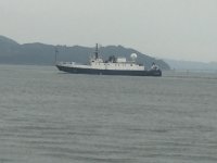
Today we spent a couple hours as the guest of Dr. Loren Davis, an Antropology professor at Oregon State University, aboard the exploration vessel Nautilus. He will be leading an expedition aboard this ship to search for early submerged landscapes and the archaeological sites they may hold near Heceta Bank off the central Oregon coastline.

Loren is my nephew and he invited Lois, me, his mom (my sis) and my daughter aboard for a tour of the amazing ship and a brief lecture on the studies they are doing offshore.

Here is the ship tied to Pier 1 at the Port of Astoria:
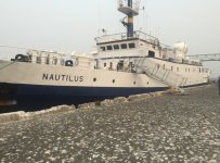
IMG_2129.jpg


This is the smaller of two Remotely Operated Vehicles. These ROV units, dubbed Argus and Hercules, were used to explore the wreck of the Titanic and many other historical undersea sites.
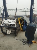
IMG_2133.jpg


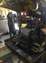
This is the best shot I could get of the larger ROV that does the real work undersea. The smaller ROV is tethered to the ship and the larger one is tethered to the smaller. This arrangement helps the working ROV remain independent and unaffected by the movement of the ship on the surface.
IMG_2132.jpg

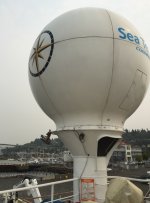
This is the antenna array that transmits the data collected by the ROV to a satellite in space and back to earth where it can be viewed on the internet a mere 20 seconds later than live at www.Nautiluslive.org.
IMG_2134.jpg

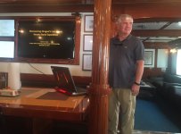
And this is my sister's kid, Loren G. Davis, Ph.D.
IMG_2141.jpg

I didn't get any good pictures of the control room where they operate the ROVs because I was too busy paying attention to the fascinating discussion by the team member who led our tour. The same goes for the bridge. The instruments at the helm are a bit more sophisticated than the ones on my boat! There are thrusters and stabilizers on the hull which are controlled at the helm with the aid of computers and GPS to allow the ship to remain at a precise spot on the water regardless of sea state, or to move with precision along a mapped course.

It is all fascinating stuff. If you go to the www.nautiluslive.org website you can follow along with the expedition.
 
Thanks for posting this, Mike. I saw this vessel down bound yesterday, I think, and was puzzled about it.

Their research could establish whether there were humans living on our coastline 10,000 plus years ago, when sea level was a lot lower, and "the beach" was many miles west of where it is today. It could alter significantly the common hypothesis that this continwnt was populated about 12,000 years ago (plus or minus!), by peoples traveling along a land bridge connecting Siberia to where Alaska is today.

Big stuff for the history of the native populations here.
 
Thanks for posting this, Mike.

Seeing pictures of the vessel and learning a little about its mission is the kind of thing makes me wish I had multiple go-arounds at life. Lord knows, I've got no right to complain about the one I've had, but still . . . I mean, boats AND anthropology!

Your nephew sounds like quite the guy. Thanks again for sharing.
 
...transmits the data...to a satellite in space and back to earth where it can be viewed on the internet a mere 20 seconds later...


And yet I sometimes can't get the printer at work to print...
:lol:
 
AstoriaDave":1vabypf5 said:
Thanks for posting this, Mike. I saw this vessel down bound yesterday, I think, and was puzzled about it.

Good morning, Dave.

Do you happen to know Jerry Ostermiller, the long time director of the Maritime Museum and an expert in underwater archaeologist and historian? He was on board with his wife for the tour and we talked briefly. Loren says he was instrumental in setting up the study of which this expedition is a part.

He is very interested a getting a C-Dory 25' Cruiser and said he has looked longingly at the one moored in the West End basin and at mine in its slip in Warrenton. I invited him to join us on here.
 
Here is a copy/paste from one of Loren's emails detailing the study and the purpose of this expedition.

  • Finding Oregon's Lost Coast: Searching for Submerged Landscapes and Archaeological Sites Near Heceta Bank
    From September 6-11, Dr. Loren Davis of Oregon State University will lead a scientific expedition to map areas of Oregon's central coast for submerged coastal landscapes and to search for evidence of early sites along ancient coastlines. Funded by the National Oceanic and Atmospheric Administration's Office of Exploration and Research (http://oceanexplorer.noaa.gov), and in collaboration with the Bureau of Ocean Exploration and Management (https://www.boem.gov and at http://www.submergedlandscapes.com), this project will take place aboard the Ocean Exploration Trust's E/V Nautilus.

    Continuing the mission to document unexplored regions of the ocean, the Nautilus team will conduct geophysical surveys near Heceta Bank to search for ancient coastal landscapes and possible archaeological sites that may have been above above sea level 21,000-15,000 years ago. Conducting high-resolution seafloor mapping and conducting short ROV dives to groundtruth data, Earth scientists and archaeologists will use this data to learn more about past coastal environments and prehistoric human migration.
    The question of how and when humans migrated from northeastern Asia into North America is a significant archaeological topic. Twenty thousand years ago, when the last Pleistocene ice maximum was in full swing, great ice sheets locked up much of the Earth’s water, and sea level was lower by 120-¬135 meters (394 – 443 feet) than it is today. In most places, the sea was at the outer edge of the continental shelves, which were carved by fluctuating sea levels during the advance and retreat of ice sheets. Flora and fauna along these ancient shorelines was likely quite different, though little is known of these areas because they are hidden deep in the ocean.

    The first human explorers to reach North America arrived during the last glacial period, in which sea levels were low, possibly by using watercraft to skirt the edge of ice sheets or by walking along unglaciated coastal tracts. If some of these early migrations were along the coast, we need to look on the continental shelves for evidence. Archaeologists hypothesize the earliest archaeological sites in the New World may be found along the northeastern Pacific Ocean’s coastal margin where they are buried in submerged terrestrial landforms that were once part of exposed ancient coastal landscapes.

    North American Pacific coastal sites are younger than North America’s earliest interior sites probably due to geological processes along the Pacific Coast that destroyed, buried, or submerged earlier sites. If the hypothesis that the Americas were initially peopled by coastal migration is correct, then the northeastern Pacific coast is a critical area of archaeological concern. However, at this time, nothing is known about North American Pacific coastal sites dating between 14,500 – 12,800 years ago--the period that is contemporaneous with the earliest evidence of New World human occupation.
    Expedition Objectives
    Nautilus will conduct surveys with geophysical instruments, ROV Hercules, and ROV Argus to search for, locate and study late Pleistocene-aged submerged terrestrial landforms and possible prehistoric archaeological sites on Oregon’s continental shelf.

    • Conduct multibeam sonar and subbottom profiler surveys within and surrounding the reconstructed drainages of paleorivers that ran through the Ice Age coast of Oregon.

    • Focus geophysical surveys on areas of the Pacific outer continental shelf corresponding to the projected position of shorelines 21,000-15,000 years ago, near a prehistoric peninsula (present day Heceta Bank).

    • Collect imagery of submerged terrestrial landforms and seafloor conditions in two areas of the ancient stream drainages (see Area 1 and Area 2 on the paleocoastal map below).

    • Collect geological and biological samples from these submerged terrestrial landforms and ancient stream drainages

    For more information, visit the Ocean Exploration Trust's webpage at:

    http://www.oceanexplorationtrust.org/


    Follow us Aboard the Nautilus

    The Nautilus is a unique research vessel, offering live video feeds of onboard work and real-time discoveries. You can follow the expedition by watching live cameras aboard the Nautilus at:

    http://www.nautiluslive.org/

    You can also send in questions to the expedition via the Nautilus Live portal.

    Follow the expedition on Twitter: @EVNautilus, @LorenGDavis

    and on Instagram: lorendavis2640


    Best regards and wish us luck!

    Loren
 
Oh WOW, that is cool. Thanks for sharing that one Mike. Would love to be on fly on that wall for a while, like a few months. Pretty exciting.

Harvey
SleepyC :moon

1_10_2012_from_Canon_961.highlight.jpg
 
Tyboo wrote: Good morning, Dave.

Do you happen to know Jerry Ostermiller, the long time director of the Maritime Museum?


Yup. Also, Lynn worked for me a couple years as a lab tech. Jerry was active as a diver on ancient wrecks, years past. His interest in maritime archeology goes way back.
------

And thanks, Tyboo, for that piece off the web site. This could break down some barriers.
 
I had not heard about this, and am very interested. What was on the coast several thousand years ago and now submerged has fascinated many of us. Great that some stabs are being made at answering this. And of course every answer will raise a magnitude of other questions.
 
Back
Top