C-Nile
New member
- Joined
- May 9, 2008
- Messages
- 638
- Reaction score
- 0
- C Dory Year
- 2012
- Vessel Name
- Betty Ann
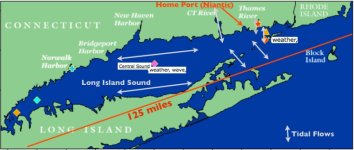
I completed the design of a matrix, customized for the area of Long Island Sound we frequent, that shows the maximum potential wave heights dependent upon wind direction, velocity and fetch. All we have to know is the wind speed, direction and our intended destination, and we can use the matrix to predict the potential maximum Sea State with no surprises.
[url=http://www.c-brats.com/module...w.c-brats.com/modules.php?set_ ... _photo.php
We correlated our results with LIS buoy data and actual experience. So why go through the trouble to do this?
Over half the time, whenever we made future plans for boating on Long Island Sound, NOAA forecasts for wave heights did not reflect actual conditions -- on many occasions, even one hour before leaving for the shore! This has been totally unacceptable. We don't want to start a 60 mile trip going into a three foot head sea that could worsen, when we are expecting two feet or less. It's not a matter of safety, but rather a matter of comfort. Boating is supposed to be fun, and it is not fun taking 4 or 5 hours to go 60 miles in difficult head seas, and making constant adjustments. Accordingly, we began late last year to disregard NOAA predictions for wave height, paying more attention to wind velocity and direction at the moment we leave our house. When we arrive at the water, we will set the direction we travel based upon the wind direction and velocity at that time. We can also assess the Sea State visually based on the Beaufort Scale to further corroborate wind speed and velocity with NOAA current conditions. Generally, we will not venture out in conditions exceeding a three feet head sea (we would go out in three foot following seas, or head seas with long wave periods if the distance was reasonable), but as I said, this is more a matter of comfort than safety. The entire C-Dory family and its cousin, The Marinaut 215, are extraordinarily seaworthy boats.
What do you think about this, and has anyone taken similar action?
[/url]

