Pat Anderson
New member
- Joined
- Nov 2, 2003
- Messages
- 8,562
- Reaction score
- 0
- C Dory Year
- 2005
- C Dory Model
- 25 Cruiser
- Vessel Name
- Daydream
Finally, frustrated no more! Our Coastal Explorer nav system is installed and working!
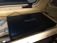
The heart of the system is a Toshiba Satellite laptop that is sitting on the shelf behind the center window. It is set up to run with the lid closed when not running on battery. I got this used for $140 on Craigslist. It is running Coastal Explorer, which I was able to get via upgrade for $99. It is outputting to a USB monitor that I got on Amazon for $99, on a bracket that I got on Amazon for $15. The expensive parts were the Vesper Marine amplified antenna splitter, $242, and the Digital Yacht AIS / multiplexer, $229. The NOAA and USACE digital charts were of course free. I also have a wireless mouse, and will get a wireless keyboard. So I am into this a little over $800.
The laptop (sorry, it is a bit blurry):

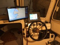
It outputs to a USB monitor mounted on a bracket than hangs down from the electronics shelf.

The laptop is running the current version of Coastal Explorer with all the free NOAA and USACE digital charts for the West Coast and the Great Loop. It gets its NMEA data, including location, speed and course, from the Raymarine C-80. The magic link is the Digital Yacht AIS / multiplexer mounted behind the helm, The NMEA output from the C-80 is connected to the NMEA input of the AIS /multiplexer, which multiplexes the NMEA data from the C-80 with AIS data and then passes it to the laptop via a USB cable for Coastal Explorer to display. The NMEA output of the AIS / multiplexer is wired to the NMEA input of the C-80, so the AIS data is also available to the C-80.
The big issue was the device drivers for the Digital Yachts AIS / multiplexer, detailed in the "Frustrated" thread, but I resolved that this morning and now have the FTDI drivers installed, and all is peaches and cream!
The only potential addition I might make is a Quantum Bytes PC, which is about $170, on which I would install a second copy of Coastal Explorer and all the digital charts. The Rose Point license allows installation on three PCs. The Quantum Bytes could be mounted on the shelf in the vee-berth, and then the Toshiba laptop would be a backup computer if the Quantum Bytes computer were to crash. Maybe overkill, I'm not really sure.
The installation of this system was all driven by the fact that we do not have chart chips for our antique C-80 for the Great Loop. The Raymarine is 11 years old and uses the obsolete CF (compact flash) cards from Navionics. Navionics has stopped selling CF cards, but even if they were available, it would cost a fortune for all the CF cards for the Great Loop, plus, I don't even know if Navionics has cartography for the river system.
All in all, I think this is a pretty workable solution, and Coastal Explorer just has the greatest interface for voyage planning.
Our back up will be an iPad and two iPhones running Navionics. If the PC crashes, we still have the Navionics for location and the C-80 for depth, radar and maybe AIS if I can figure out how to display AIS data on the C-80 display!
The heart of the system is a Toshiba Satellite laptop that is sitting on the shelf behind the center window. It is set up to run with the lid closed when not running on battery. I got this used for $140 on Craigslist. It is running Coastal Explorer, which I was able to get via upgrade for $99. It is outputting to a USB monitor that I got on Amazon for $99, on a bracket that I got on Amazon for $15. The expensive parts were the Vesper Marine amplified antenna splitter, $242, and the Digital Yacht AIS / multiplexer, $229. The NOAA and USACE digital charts were of course free. I also have a wireless mouse, and will get a wireless keyboard. So I am into this a little over $800.
The laptop (sorry, it is a bit blurry):

It outputs to a USB monitor mounted on a bracket than hangs down from the electronics shelf.

The laptop is running the current version of Coastal Explorer with all the free NOAA and USACE digital charts for the West Coast and the Great Loop. It gets its NMEA data, including location, speed and course, from the Raymarine C-80. The magic link is the Digital Yacht AIS / multiplexer mounted behind the helm, The NMEA output from the C-80 is connected to the NMEA input of the AIS /multiplexer, which multiplexes the NMEA data from the C-80 with AIS data and then passes it to the laptop via a USB cable for Coastal Explorer to display. The NMEA output of the AIS / multiplexer is wired to the NMEA input of the C-80, so the AIS data is also available to the C-80.
The big issue was the device drivers for the Digital Yachts AIS / multiplexer, detailed in the "Frustrated" thread, but I resolved that this morning and now have the FTDI drivers installed, and all is peaches and cream!
The only potential addition I might make is a Quantum Bytes PC, which is about $170, on which I would install a second copy of Coastal Explorer and all the digital charts. The Rose Point license allows installation on three PCs. The Quantum Bytes could be mounted on the shelf in the vee-berth, and then the Toshiba laptop would be a backup computer if the Quantum Bytes computer were to crash. Maybe overkill, I'm not really sure.
The installation of this system was all driven by the fact that we do not have chart chips for our antique C-80 for the Great Loop. The Raymarine is 11 years old and uses the obsolete CF (compact flash) cards from Navionics. Navionics has stopped selling CF cards, but even if they were available, it would cost a fortune for all the CF cards for the Great Loop, plus, I don't even know if Navionics has cartography for the river system.
All in all, I think this is a pretty workable solution, and Coastal Explorer just has the greatest interface for voyage planning.
Our back up will be an iPad and two iPhones running Navionics. If the PC crashes, we still have the Navionics for location and the C-80 for depth, radar and maybe AIS if I can figure out how to display AIS data on the C-80 display!


