Garmin Colorado 400C On sale At West Marine

morris_rl

New member
West Marine dropped the Garmin Colorado 400C GPS in price from $599.99 to $349.99 in the month of January 2009. This unit has coastal charts for the "Lower 48" already loaded, and it can be updated. It can also take topographic maps and highway maps via a memory chip.

I bought one and ordered a 12VDC "cigarette lighter" power adaptor. It took about a week to come in. When I went to the Ventura (southern California) West Marine store to pick up the adaptor cable, I saw that the sale price had been dropped to $339.99, but I did not think to check how long this will be so.

Per West Marine's "30 day" policy, I presented my purchase receipt for the GPS and West Marine credited my visa card with $10.72 without flinching.

As I understand it, the Colorado 400C with the knurled knob (one-handed operation) came out last year and is being replaced with a GPS unit that uses a touch screen interface. The replacement unit will reportedly cost $600.00 or thereabouts.

Regards,
 
Rodger:

I think you're going to enjoy the Colorado C. You got the right version, and the right accessory (the 12 v plug adaptor).

The Colorado comes in three versions, with the C being loaded with Garmin's coastal cartography. The other two are of no interest to boaters. If you get the C, you can buy the chips to make it run like either of the other two versions (for about $100 - $125). But if you get either of the others, and want to run nautical charts, you have to buy chips for individual regions, or the whole coastal series for about $1100. Moral of the story: if you plan on using the unit on the water, buy the C, and get chips for other uses later.

The Colorado C is somewhat of a power pig, and only has two AA batteries. So, to conserve power, it's screen will not go full bright unless connected to an external 12v source. Once you have that connection, the screen can be made to go very bright.

The touch screen version is the Oregon. It's available now, but I greatly prefer the Colorado. The knob allows you to change scale quickly, which is a must on small screen units.

Have fun.
 
This is a great little GPS -- I bought one in December at West -- I think the wheel is even better than the touch screen for marine use because when its attached to the boat you can more easily control menus with the wheel with one hand.

One suggestion -- buy the 12v adaptor with the DSC pigtail so you can attach the GPS to your primary VHF's DSC. I don't think it costs any more than the 12v alone adaptor.

I have a chartpotter I use on my laptop -- which gives much more detail in a 15" screen -- but I find that with the Colorado I am leaving the laptop at home more and more. The Colorado lets you zoom in and out very easily so as to see local shoreline hazards.

Enjoy!
 
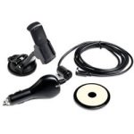
Took the plunge and also bought the car mount with 12v power adapter, figure the suction cup would work in the boat. Got the North American city map SD card off Amazon for our trip down to Seattle and Vancouver next month. See the price has also come down on Amazon for the 400C in just the last day but West still has the best price.
New toy! :smilep

9394578_G.thumb.jpg
 
So we are looking at either the Garmin 76CSX or this new 400C for our projected 16 cruiser. Is the price difference worth it in your opinion(s)?

Thanks,
Steve

PS Also Amazon says the 400c is a real power hog and there is no 12v adapter and yet here in C-Brat land we are saying a 12v adapter will work. Sooooo ... which is it???

Also which one of these units would work better for Midwest river cruising?
 
I got the 12V adaptor with the DSC pigtail for the VHF for about $30 from West Marine. It works nicely as a hardwired GPS. And, of course, I can easily slide it off the mount to use as a handheld.
 
There is a 12v power adapter, this is it
Yea I read that it’s a power hog and you can only get 5 hours off two AA alkaline batteries, but that seems like pretty good service for to me.

I think the 76CSX is also a great GPS because it floats and has a long history of reliability, but the 400c will take G2 maps thats why I went with it; the price is right also. Think the Oregon is more popular because its touch screen and the Colorado’s not, that’s probably why it’s on sale, just a guess.
 
Steve: the "C" stands for coastal. If you plan on using this unit on inland rivers, check the following site to assure yourself that the cartography you want is available:

https://buy.garmin.com/shop/shop.do?cID ... 024#mapTab

I suggest you start with Inland Lakes.

As already shown by photos and and text in various posts already made to this thread, 12v power cords are available, no matter what Amazon says. You can confirm this by clicking on Garmin's "Accessories" tab for the unit. The power cord is a must for this unit, because it's power management software will not let you light the screen up to the maximum brightness without the external power source.
 
I ran out and picked up one of the 400C Colorado's this AM. (With 12 volt adaptor)--I also had read some of the reviews. There have been some improvements, or the reviewers didn't figure out how to use the unit. I have more than 4 hours on the battery, and it still shows near "full" charge. You can get Lat and Lon of the current position. I get a bright enough screen to be seen in full sunlight. The wheel takes a couple of minutes to learn, but actually is a very intuative way to use the unit, especially in a bouncing small boat. It also has tides in the C version, as well as currents.

If you are never going to use the boat in salt water, then the inland lake version certainly makes sense. I looked at the inland lakes plus the Topo DVD (of the entire US)--and decided on the topo. I will load my own SD cards, and it is just a little over $100 extra. The reason I went with topo over the lake, is that for many rivers and lakes it labels the points and land features better than the lake versions, plus has rural roads, which often are valuable. The lake charts--will give bottom contours, which will be better for fishing. But for cruising, the Topo seems as if it will do better for me.

Before you decide which version--check out the cartography. Plus I don't know if the 400i is at $339?
 
Most RV shops have altimiters (they are barometric, but I have found them to be accurate. Airguide and Swift both make these for about $50 give or take. I have also seen these at Wal marts in the RV part of the auto section.

I have to assume that the Colorado 400i altimeter is pure barometric, since you can also trace barometric pressure on a graph. (Vs reading the altitude from the gPS-some of the newest units are pretty good with this, but the older units were not.

I would say that if you were within 200 feet you were doing well with any of these units, except the more expensive units used by parachutists.
 
Doryman":2orwnse4 said:
Anyone know of a good, inexpensive altimeter? I am not interested in buying a new GPS just for that feature...

Warren

If you want an inexpensive altimeter try an auto parts store.

For an altimeter to be accurate it must be barometric, Pure GPS altimeter technology is lousy; I get this from my pilot friends.

Flying c-dory’s :?: think we need another forum for this one.
 
I'm off to the summer job here shortly & thought it would be good to get some fog insurance. That Colorado 400c looked like just the policy I needed so I marched down to West M to investigate. I thought for sure that the unit wouldn't have squat for chart coverage for Cross Sound AK and that I have surely missed out on the big sale. I fondled the unit and discovered it had excellent detail for the summer waters & after cajolling the manager dude, got him to cut it loose for $345...hot damn, bring on the fog.

I scared up a sturdy old camera bag that holds the garmin and the hand held vhf and some extra batteries like it was made for them. life is good
 
Back
Top