Help Please! Thoughts on Weather in Gulf over Next Week?

Pat Anderson

New member
We are in Demopolis, about to head down to Mobile, which is about a five day trip. Today (Tuesday, October 3rd) people in the TV room here at the marina were glued to the TV weather, which was talking about a tropical depression off the Gulf and the possibility of a tropical storm which might hit Saturday or Sunday. Winds in Mobile are very strong right now. We were going to leave Demopolis tomorrow, but have extended for one more day, and will play it on a day by day basis. We'd love to hear from anybody who has any thoughts on what their crystal ball says the weather in Mobile and the Gulf of Mexico for the next week or ten days might look like! Thanks!
 
Hi Pat,

If I could predict the Gulf weather 10 days out, I would be buying lottery tickets. Here is my preferred tropical weather site...

https://www.wunderground.com/hurricane

As of right now, there is no hurricane or tropical storms happening in the entire northern Atlantic. If you click further into that site for this...

https://www.wunderground.com/cat6/calm- ... ntic-storm

There is still potential. They are saying the northwestern Caribbean shows the most risk of development currently, with a "near zero % chance of development before this Thursday, and a 30% chance of development through Sunday."

Not even the weather forecasters are making guesses further out than that.

The Gulf and most of the Atlantic is warmer than usual, making for the increased chance of development as lows form in that area. The best advice I can offer you is to check this site regularly. If something develops in the NW Caribbean, the eastern Gulf is more likely to be involved.

This calm that we are now experiencing does not mean that hurricane season has passed; October can still be active, and even into November. Don't spend the time worrying about this - just keep an eye towards the Caribbean.

Hope all goes smooth and easy for you on this last portion of your trip. The Florida Gulf Coast is a pretty area.

Best wishes,
Jim
 
Looking specifically at the Mobile area, here's the 10 day forecast...

https://weather.com/weather/tenday/l/USAL0371:1:US

It is showing a 60% chance of scattered thunderstorms for Saturday and Sunday, with the highest wind currently predicted to be 14mph ESE on Sunday. That does not equate to a tropical storm, but I generally don't trust weather forecasts much beyond 48 hours out. Once you get past Mobile Bay (which can be like Bellingham Bay depending on wind conditions), you are in mostly protected water as you head east.

Dr. Bob may have a more specific take on this, with his local knowledge. At this point, I don't see anything nasty in the near-term.

The Weather Channel is showing winds ENE @ 10 this evening.
 
Well, as I see it, you have a few day window to get to Mobile Bay, depending on the forecast. Your ultimate destination is the Caloosahatshee Canal to load your boat and get the hell out.

And here are the options, you may think of better ones:

1. Stay put until hurricane season is over, up to a month's wait. Then complete your trip.

2. Get to Mobile Bay and wait for a week or 2 window to get to the Caloosahatshee Canal and complete your trip. This may take several weeks and Mobile Bay is on the Gulf Coast and may get hit.

3. Leave your boat where it is, go get your truck and return, load your boat and say the trip is complete.

You're going to have to go through the armpit of Florida after you leave Mobile. Protected water, yes, but good chance of storms there, I understand.

No-one can predict the appearance or path of a hurricane, at least until the season is over. Your trip is almost over, so why take chances now? Take option 1, rent a car and tour north of Demopolis, monitoring the weather until you feel comfortable. The C-Dory is a wonderful boat, but I'd hate to ride out a tropical storm in one.

Boris
 
Pat,
We've been following your adventures, and this should be a non-event.
Just hang out north of the I-65 bridge, in one of the many ox-bows or inlets, and you'll be fine.
Any Tropical force winds will be down to 'damn the bugs' levels there.
We probably won't have any tropical storm winds at all...it will go into Central America.
Chill, have an extra sundowner on us, and relax.
As you know, I am always the outlier here, but I think you'll be fine.
We would invite you guys into our military marina if it was legal to do so.
Chill! Fun! No Worries!
you'll be fine!
John
 
Well, Saturday and especially Sunday might be rough. Seems like you might consider moving day by day at your normal 50 mile per day rate. Maybe have a good plan for Friday. Here is the link I used (I am a subscriber for $10 per year but think it will work for you).
https://www.wunderground.com/forecast/u ... bile/36601
If the radar page will open for you, I see very little in your area all the way down to Mobile. There is some weather east and west however.
Love the pictures of Baxter, did you try to teach him to use a mat on the bow?
Bob
 
Pat, Don't know know much stock you can put in the PNW weather guys, but just tonight KIRO 7 flicked to a view of the Gulf, and showed a Low system over Panama, and he said, This one bares watching. The Gulf water is still very warm, and the progression will be northward.

Guess it pays to be attentive.

Harvey
SleepyC :moon

1_10_2012_from_Canon_961.highlight.jpg
 
Like Jim,
I don't have a crystal ball. Today was one of the nicest days we have had this year. Didn't see any "strong winds"--maybe 10 knots.

You are 5 days from Mobile. As noted lots of places to hang out--if you really get stuck, we can get extra anchors to you, or even a trailer to get the boat out of the water.

I watch the Tropical weather daily--we are far more at any risk from a storm than folks in Demopolis.

The hurricane season lasts two more months--until the end of November. But storms can happen any time of the year. We loose more boats in Northers than in hurricanes on the average year in this part of the woods.

The "Armpit of Florida" geez..--come on Boris--have you ever even been here? We have lived in this area 25 years.. We consider it to be the best part of Florida.

We won't know exactly what will happen with Invest 90L for 5 days. There is a possible chance of tropical storm force winds. On the site I follow the most, there is only one model which shows winds over tropical storm force at 5 days--(one shows a potential Cat 2 hurricane but it is an outlier, which is rarely correct).

Current tracks show Invest 90L going to the West of Mobile--but this can change--and Windy shows it going ashore East of Panama City at 8 PM on Sunday (5 days). There is absolutely no way at this time to be 100% sure of where it is going if it is even going to be a significant storm, or even a storm...

My advice is to continue as you have planed coming South. Plenty of good holding in oxbows and creeks along the way. Keep in touch daily--I get a private report which is quite good, if we are under a serious threat.

Look at "Windy.com"--

At this time we are not taking any storm precautions in the Pensacola area. If we have a storm, in back of our house is one of the best places to ride out a storm if you want to speed up and get here sooner--or we would get you out of the water if necessary. There is a very good chance of some heavy rain--but that is all of the Gulf Coast.

The biggest body of water is Mobile bay, then Pensacola Bay, on down to the bays open to the East and West toward Fort Walton and Panama City. The latter are over a week away for you, The biggest weather concern is going to be when you make the jump to cross the "Big Bend"
 
I had never gone on this site but lots of folks have mentioned it, great info. Appears it is free to register and it found my home right away,
Bob
 
As a generalization--the predictions of possible high wind velocities have been revised downward. Only one of the models shows winds slightly above Cat 1.

The most likely tracks have shifted eastward. Tracks can be all over the place at this distance (well over 1000 miles away)

More information will be available this PM after a Air Force Reserve aircraft does some passes thru this system--just named as Tropical Depression 16.

My advice would be to crank up the RPM and get on down. However I don't see any significant winds between you and us in the next 5 days from the information available currently.

Another beautiful day in Paradise here in Pensacola. The leaves are barely moving--the Angel is dry when she comes in the house after a romp on the grass. Temperature is 78.

We do have clear weather thru Friday. Saturday thunderstorms, with some rain, Sunday, Monday, and Tuesday. The same forecast is in play for Mobile and Mobile Bay.
 
Hi Guys,
I would enjoy Demopolis. No reason to rush into harms way. As the weather forcast updates you can make your plans for
continuing the adventure. Just my idea and way to solve the
situation.
Bob
 
Hi Guys,
I would enjoy Demopolis. No reason to rush into harms way. As the weather forcast updates you can make your plans for
continuing the adventure. Just my idea and way to solve the
situation.
Bob
 
Forecast has is shifted further to the east today. Its reminiscent of hurricane Hermine last year, which came up over the panhandle of Florida as a hurricane and then directly over the top of us as a tropical storm. We'll be watching this one over the next few days.

I don't see any reason to rush. Should be to the north of you Monday or Tuesday and nothing behind it to worry about on the forecast. Inland water is the place to be not on the coast.
 
The latest computer models...

at201716.gif


at201716_model.gif


Still too far out time-wise to make an "accurate guess" (oxymoron).
 
Pat,
I'd be inclined to stay in Demopolis until this particular system passes or no longer appears to be a threat. As you know, there are no nicer places to tie up between Demopolis and Mobile. I also expect Bobby's Fish Camp may get very busy if the storm appears to threaten the Mobile area.

Les
 
Just in.
Tropical depression 16 has formed in the western Caribbean Sea... and is 25 miles SSW of San Andres Island with 35 mph wind and moving NW at 7 mph.
The depression is likely to become #Nate as it approaches the Gulf Coast this weekend. It could become a hurricane before landfall... then weaken quickly as it moves inland.
Savannah is in the cone of possible track. IF we feel any impacts... they would come Sunday into Monday... and could include minor to possibly moderate coastal flooding and isolated tornadoes. Localized flooding rainfall and tropical storm force winds (40 mph+) are also possible.
www.wsav.com/weather
 
I like Windy.com. because it gives you a choice of two Global models: it uses the European Center for Medium-Range Weather Forecasting (ECMWF) as the default. This is the model which has proven to be the most accurate over the last 15 years.

The other model used by Windy.com is the( GFS): The Global Forecast System model /This is run by the US national Weather Service. It tends to be not quite historically as accurate as the ECMWF. If you compare the two tracks on Windy.com, you have a spread at landfall of several hundred miles, and a huge difference in intensity,

At a time like this, even the Saturday Forecast does not tell use much about which way the storm is going. Many models have it taking a fairly abrupt turn to the East. Some to the West.

There are also rapidly run models (Such as BAM) which use only segments of the earth's meteorology data, and can be run in a short time and are good for short term forecast, but tend to be less accurate for longer time frames.

The Global models take hours to run, for the World's fastest computers. We don't have a lot of data over vast stretches of Oceans--all of which will affect the local weather in one locality 5 days down the line.

Even a few miles change of the low's path a few days from now will make a large difference in place of landfall. If it goes thru the relatively narrow straits between the Yucatan and Cuba, it will remain over warm water. It it goes over Honduras, and then the Yucatan, it will be disrupted by the land masses.

One generally thinks of hurricanes as wide spread storms--but usually the devastation is limited to a relatively small area if the landfall is perpendicular. if the storm runs parallel or obliquely onto the coast, it can extend for many miles as Irma did. At this time, TS 16 appears as if it will strike perpendicular to the coast line.

Absolutely the safest thing is to stay up river several hundred miles inland.
 
Thanks all! We are safe here in Demopolis, and this is where we intend to stay until we know how this storm will - or won't - develop over the next few days. This is a nice marina, and very reasonably priced, better safe than sorry!

 
Well, Bob, here's what I used to make my statements. I still firmly believe that Daydream ought to stay put until the weather changes. The trip's too close to a nice ending.

1. I've been to Florida several times. Spent a summer in Ft Walton Beach launching rockets. Later I passed through Pensacola and cut through the Gulph to Tampa. Beautiful trip, dolphins/porpoises swam with us.

2. The roughest night I've ever spent on a sailboat was in your lovely town of Pensacola. But that was a norther. I was at the outer dock of the Pensacola Yacht Club and I came away with a lot of respect for the way Catalina sailboats are built.

3. For a C-Dory 25 avoiding weather, certainly stay inland, use the ICW and pass through the panhandle.

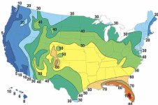
4. The first time I ever heard of the Florida Panhandle was when I saw this picture. Note the bright orange near you. I then read that the Panhandle has the most lightning strikes in the USA, or the World? Actually, that is what got us to take the Gulph route. Notice the orange and red in Florida.
florida_thunder.jpg
The average number of thunderstorm days each year throughout the U.S. Courtesy of the National Weather Service.


5. And finally the way I remember the jingle is: "July rarely, September always, November, it's over". Or something like that. If you're saying that climate change has now extended the hurricane season, I believe you; I live on the West Coast, where it's colored blue on the map.

Boris

 
Back
Top