Hurricane Michael

I can attest tha a hurricane is one of Mother Nature's worst expression of her
wrath.

In 1992 I was in H Iniki that devastaed Kauai. And in 1999 H Lenny (wrong way
Lenny... on St Maarten when I had just disembarked a 54' Swan sloop coming
from Bermuda, then experienced Lenny's "eye' a day or so later. There were
about 17 deaths from this one including 6 unfortunate mariners caught at sea.

My worst memories are in two parts for both: the terrifying storm itself with
howling winds, visual flying objects and rising water and then the chaos with
forlorn people and property damage afterwards.

I have forever been changed from these experiences.

Best of luck to all our SE residents, friends and visitors dealing with Michael and
the aftermath.

Nothing like "Home sweet home".

Aye.
 
Have not had news access or C-BRAT access for several days except for a few minutes at a diner in Cuba, NM the other day. First I had seen about H Michael, and what I saw was coming from Apalachicola. Immediate prayers went up for all of you in the path. Hope you are all safe and prepared and maybe by now, the worst is over.

I have very little experience with hurricane velocity winds. The Columbus day storm, Oct 12, 1962 blew up the west coast with winds in the 120 to 150 or 160 bracket. I was driving up the Oregon coast that day, in the middle of the storm and saw mobile homes disintegrate, big trucks blown over, and store windows blown out.... We had no electricity for 6 days.

Prayers for you all.

Harvey
SleepyC :moon

IMGP1872.thumb.jpg
 
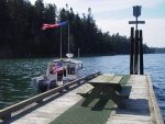
Last December I took a wonderful cruise through the areas affected by Michael. It was a fantastic cruise and I stayed at the St Andrews Marina in Panama City and the marina in Port St Joe. Both are totally destroyed. So sad. I was planning on returning this year as I enjoyed myself so much. Breaks my heart. Such character in that part of Florida.
 
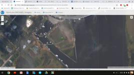
NOAA has a searchable post-Michael satellite map or the areas affected by Hurricane Michael here.

This is a screenshot the Battery Park Marina in Apalachicola where we stayed in Marc's slip about a year ago. The resolution actually seems pretty good. No damage is obvious from the image, but that could be incorrect. It does not appear that the Scipio Creek Marina, where we fueled, was in the area affected according to th satellite map, but that could be also be incorrect. A lot of Loopers who are somewhere upriver of Mobile are wondering about where they can stay, fuel up and stage for the crossing of the Big Bend.
nshot_of_Battery_Park_Marina_in_Apalachicola.sized.png
 
Good photo Pat. What we don't see in the photos is the loss of infrastructure due to 10 foot storm surge and wind damage, Even though docks look good from the air, it is our experience that the surge pulls up the pilings and causes deformity/stress in the stringers, so they have to have pilings reset. Stringers replaced and re-do the decking. Power is a problem. I understand that Mark diverted to Atlanta to pick up and then resell Yamaha generators at his cost to folks who have no power. We were without power for over a month after Ivan--this area could be longer. Internet, cable TV and cell towers all have to be established, and that comes after the power.

From what I gather at this point; Dog River, the ICW marinas to Fort Walton are going to be in business. Destin has significant damage. Panama City at this point is not having municipal marinas back in service before the first of the year, if then.Bay Point is unknown. They had substantial damage and are out on a peninsula.

The major issue is getting fuel. A gas truck got into Apalachicola yesterday, so that is good news. If I was planning this part of loop today, I would fill up at Fort Walton and go at slow displacement speeds to St. Petersburg. That is a distance of slightly over 300 miles--at 6 knots two days and nights plus. Unfortunately few loopers are comfortable with even one overnighter....One of the Carabelle Marinas claims to have minor damage, and should be back in business shortly--but power may be a problem.

It is possible that fuel can be arranged directly from tanker trucks in a place like Apalachicola in several months, If there are in ground tanks, they would have to be dewatered and cleaned. Above ground tanks have to be repaired if damaged.

Another unknown is the status of the gulf coast ICW between the Eastern part of Panama Ciry Bay to Apalachicola. Several times in the past there have been tree falls, debris and bank washouts which have closed the ICW. I have not yet seen any reports of the condition of the ICW there or even between the Destin area and St. Andrews bay.

I have also had phone calls from loopers asking about the status. I have told folks to watch the Waterway Guide updates:Here for daily updates.
 
The last few years have been really tough times for Apalachicola Bay Oysters. Marc may weigh in with better data at some point, There have been multiple challenges even before the Hurricane. Currently all beds are closed. The issues have been fresh water/salt water mix, restriction of fresh water (Political) and drought or flood conditions. There is disruption of oyster beds by storms--and especially by Michael. There have also been viral issues, the Dermo disease, predatory southern oyster drill and boring sponges. The spat production seemed to be fairly good last year, but Oysters making it to maturity declined. Add in sanitary issues not only in the town/bay, but upstream along the Apalachicola river, it looks like a tough time for oysters!

I have no information on the stone crabs--the would be in season this next week, but I suspect the storm disrupted the habitat badly.
 
Update from here .We are so very fortunate! I am sitting in my office in Eastpoint with power on , internet working and zero damage to any boats that are here . We will open with full staff tomorrow in a fully working facility . One of our employees lives on St George Island and was flooded out . They are ok but home is uninhabitable . Apalachicola got about 6'maybe 7' of surge flooding . So the places that get the usual flooding did flood [mostly along the river] and this is a bit higher that has been seen in anyone's memory. Definitely not 10' . Just 30 miles from us they saw 14' foot wall of destructive surge and winds that broke the Tyndall AFB anemometer at 129 MPH.Everything else broke at Tyndall AFB as its completely destroyed along with 3 F 22s [300 mil. a pop] and a bunch of high tech drones .2 of my friends boat dealerships on the east side of Panama City were total losses. Lots of Marinas damaged .Many tornadoes were spawned and broke trees and homes damaged or destroyed well into middle Ga.
This time around Apalachicola was an island of relative safety .
Thanks for all that reached out and if you can help our neighbors to the west please do as they sorely need it .
Marc
 
Just finished potato harvest in Puget Sound/Skagit Valley area in WA. Glad to hear Bob, Marc, and other FL brats are OK. Marc, I sent you a text. Bob, PM me your number please. I have a week I could come down if yall have friends that need help. I have to be back up here 23-24Oct to drive back cross country.
Byrdman
 
Back
Top