I-5 bridge collapse.

thataway":1akxfz5d said:
Where is the Army Corp of Engineers with the mobile bridges which have been used for many years for temporary spans? Some of these will allow Army tanks to cross on them.

If that one segment went down that easily, I sure would wonder about the rest of the remaining bridge, which is similar.

Yesterday's Everett Herald stated that "Officials are scouring the nation for one of the WW II era structures known as a Bailey bridge, a type of portable bridge used by the British and American military engineering units during the war. If one of these bridges is available to span the 160 foot gap and if it can be held up by the remaining structure, travel on the freeway could be restored in a matter of weeks".

Today's Everett Herald stated, "Crews plan to begin removing wreckage of the bridge as early as today. Barges were scheduled on Saturday evening to bring in heavy cutting and lifting equipment to prepare for the work. The equipment includes a disassembled 150 ton crane that will be reassembled at the scene.....crews must remove the fallen span from the river before final inspections of the bridge and piers can be completed".

(One of the news medias reported and displayed a picture of additional damage caused by the oversized load to other portions of the bridge that did not collapse into the river.)
 
There's another bridge on I-5 that would be a major disaster if it were lost, the Pit River Bridge over Shasta Lake, just 15 minutes north of Redding.
It handles not only all the load of trucks and cars on I-5, but also all of the train traffic gong north/south in on the
West Coast that doesn't go around the backside of the Sierras and the Cascades.
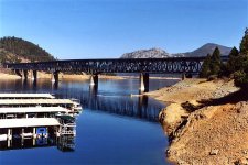
212423713_cee12440cd_z.jpg
(My CD-22 and Sea Ray SB-265 are in the covered marina in the photo above.)

Here's an article on what it's loss to terrorism or a natural disaster (earthquake) would mean:
(from the Redding Record-Searchlight, 2007)

Caltrans Braced for Disaster: Department Has Contingency Plan for Pit River Span


Ed Lamkin of the California Department of Transportation gets paid to think the unthinkable -- what would happen if terrorists or some other disaster disabled or destroyed the Pit River bridge over Lake Shasta, a road and rail link vital to West Coast transportation and commerce?

At a minimum, he said, it could mean months if not years of diverting traffic on a time-consuming 125-mile detour through Burney or on roads to the coast.

"It's a big concern of ours," Lamkin said this week. "We have been leery of it (a terror attack) since 9/11. It certainly woke us up."

Lamkin, a 50-year-old engineer who grew up in northern Michigan, is deputy district director for maintenance and traffic operations in Caltrans' Redding office. He carries a contingency plan wherever he goes. It includes traffic diversion and detour scenarios, and pages of contact numbers.

The Pit River bridge, a 3,600-foot-long span completed in 1941, sees an average of 37,800 vehicles a day, about a quarter of them trucks. Union Pacific trains pass on tracks under the roadway. The bridge is undergoing work to replace its aging deck, a $21.5 million, two-year project scheduled to be finished in June 2008. (Caltrans originally reserved $50 million for the work, Lamkin said.)

The bridge is "extremely vital" to transportation and commerce on the West Coast, Lamkin said. If it were put out of commission, the cost to users would be $4 million to $5 million a day, he said.

A Timothy McVeigh-style truck bomb "would likely result in a hole in the deck" rather than the loss of a span, Lamkin said. "It's a very strong structure," he said of the concrete and steel-truss bridge. The bridge was built to support two trains at once, he noted. There's only one active track on the bridge. Given the "extremely large concrete piers" that support the bridge, Lamkin said, "I don't see it being vulnerable from the lake (side)." When the lake is full, there's only about 25 feet of clearance between the bridge and the lake surface, he said.

A camera on the bridge is monitored in Caltrans' traffic management center on Riverside Drive in Redding. The agency "works very closely" with the California Highway Patrol to protect the bridge, Lamkin said, declining to offer specifics.

The CHP has beefed up patrols in the area and has officers on the bridge 24 hours a day during holidays and at peak travel times, said Joe Micheletti, a lieutenant at the CHP's Redding area office. "But it's almost physically impossible to 100 percent protect these infrastructure items," Micheletti said. "You have limited resources and do the best you can. We rely on the eyes of the public, too."

Earlier this year, thieves stole tools from a Union Pacific storage shed at the north end of the bridge. The engineer of a passing train noticed the theft in progress and notified law enforcement. The suspects were arrested moments later near the Turntable Bay interchange, said Tony Pascal, a Caltrans engineer.

After the Sept. 11 attacks, construction plans for the bridge are "considered sensitive information," Lamkin said. "We're not going to give copies of the as-built' plans to any contractor who hasn't undergone a security background check." Martinez-based Gold State Bridges is the general contractor on the deck job.

If serious damage occurred to the structure, Caltrans would award an emergency contract to fix it, Lamkin said, similar to the contract awarded to C.C. Meyers Inc. to repair the Santa Monica Freeway after the 1994 Northridge Earthquake. The contractor received an incentive to complete the work quickly, a contract provision that resulted in an additional $14 million payment, he said.

The bridge was built and is owned by the Bureau of Land Management. Caltrans and Union Pacific are responsible for maintaining the structure.

To replace the bridge today would cost $500 million -- "a real ballpark estimate," Lamkin said. It was widened in 1966 to four lanes with two-foot shoulders.

Caltrans "would like to replace the bridge in the next 20 years," he said.

"That bridge is extremely strong," Lamkin said. "With proper maintenance and painting, it could last another 100 years."

NOTE: Cal Trans is currently replacing the second bridge over Lake Shasta at Lakehead, ~15 miles north of the Pit River Bridge. It does not carry train traffic, but is also a single/vital link of I-5. -Joe.)


Joe. :teeth :thup
 
That bridge sure sounds more important than a bullet train!

One of the Bailey Bridges was being used to re-route traffic to "Tremont Camp Ground" in the Townsend, TN,a year ago, as the new bridge was being built. there were 45,000 lb motor homes going over it on a regular basis. It was only a single lane--about 10 feet wide.
 
thataway":30341s6k said:
That bridge sure sounds more important than a bullet train!

One of the Bailey Bridges was being used to re-route traffic to "Tremont Camp Ground" in the Townsend, TN,a year ago, as the new bridge was being built. there were 45,000 lb motor homes going over it on a regular basis. It was only a single lane--about 10 feet wide.

Bob-

We're going to name the bullet train "Brown's Final Folly", and the big tube through the Delta "So-Cal Sucks, Pt II".
The first is sad waste of money and second an environmental disaster in the making.

Were there waves, chop, winds, and current on the river for the RV "Pilots""? :smileo

Joe. :teeth :thup
 
Thanks for the feed back on the detours. I looked at the 221 exit plan and it looks like a good route. That's Fir Island road..Best Road...to 20 correct?
 
Gene Morris":3kzaorzw said:
Thanks for the feed back on the detours. I looked at the 221 exit plan and it looks like a good route. That's Fir Island road..Best Road...to 20 correct?

Currently the recommended detour for Northbound traffic is:

I-5 Exit 227 NB to E. College Way >>>Rt turn onto E. College Way (also 538)
in about 2 blocks >>> Lt onto Riverside Drive (you will be going North bound then) about a mile to a bridge parallel to I-5 across the Skagit
then continuing about 3/4 mile north to George Hopper Road to turn left
Left or west bound on George Harper Road about a block, and take a right onto I-5 North Bound. You will be getting back onto I-5 at exit 229, (Important to remember for reversing the process on the return southbound.)

Gene, I hope that helps in time.

Harvey
SleepyC:moon

0_CD_Cover_SlpyC_with_Classics_MBSP_2009_288.thumb.jpg
 
Joe, the portable bridge in TN spanned about 150 feet. and temporary supoports on both river banks. Lots of current, especially during flood times (but the bridge was about 15 feet off the river. The new bridge was going to have two supports in the river. You would wonder if one truck at a time over a temporary bridge wouldn't be faster than the detour...In any case it appears that a new bridge would be on order shortly!
 
We hadn't been on this site for a few days because we were in Victoria, BC, with friends. We got back to Anacortes on the ferry yesterday, and today we headed south and east, toward Texas. On I-5, near Burlington, we saw a sign with flashing lights, telling us to turn on the radio for info on road conditions, which reported two bridges closed on I-5 over the Skagit River. Of course, we didn't know what was going on, but we had to get off I-5 at Hopper Rd. We went east on an overpass to Burlington Rd., south over that bridge and on southward to Hwy. 538. We had no problems in that area, on the detours, pulling our 16' C-Dory with our pickup and camper. There we chose to go east on to Hwy. 9, which we took south to Arlington, where we were able to get back on I-5. When we passed the I-5 bridge in Burlington, we saw that a huge chunk of the span, girders, etc., was down on the ground. So now we know what happened, thanks to C-Dory news! (Though we still don't know why the I-5 bridge at Mount Vernon was closed. Anyone have news of that?) We went on down to Everett and took Hwy. 2 heading east, and the traffic heading west toward Seattle was horrendous, bumper-to-bumper, backed up for probably 50 miles, but that may be usual at the end of the Memorial Day weekend, with everyone heading home! We're glad to hear only 3 people were injured in the collapse of the span, and we're also glad that today we were heading east, not west!
Lyle, Janda, and Lindy
 
Back
Top