IPad 64G, WiFi, 3G, 1st Gen, $499, Target

JamesTXSD":2wjy4ih1 said:
Walldog":2wjy4ih1 said:
JamesTXSD":2wjy4ih1 said:
I see the Navionics app is back on the App Store for the iPad... at a higher price, $49.99.

$14.99 for the iPhone. Guess they could see where the market is. I know a lot of folks are using the iPhone, but the iPad is about the same size as the most popular 8" dedicated chartplotters. Still, not a bad deal for what you get, but as near as I can tell, what you get for your additional $15 (from the previous price of $34.99 for the iPad app) is a "bug fix" for iOS5.0.

My upgrade to iOS5.0 went smooth. Looks like my 34.99 app upgraded also. So new stuff, with tides and currents for favorite locations. Doesn't seem to get tide info for gps position easily though.

Yep, thanks Jim that works. I have Port Isabel and Anacortes set as favorites, but it is nice to see tides where we are actually located.

Hi Herb,

We have found the local tide info easy to pull up. Either go to Search and pull up the Tides folder; you should get all the tide reporting stations in the near area. If you want to know the tide info on another location, scroll to that area on the chart, press and hold near any "T" (tide reporting) on the chart until the magnifier comes up, center that on the "T" and it pulls up that tide info.

Hope that helps.

Best wishes,
Jim
 
I don't mean to get off subject, however I do believe that the Wifi only Ipad has a GPS chip. The location function seems to work great on my Ipad (Wifi only), it finds me whereever I am including walking around the neighborhood. For the map app to work it need connection to Wifi, but Wifi is not providing location data. What do you think?
 
The wifi only chip doesn't have a gps chip. It get location from detecting wifi stations nearby and knowing their locations. It's accuracy can be pretty good in an area of dense wifi stations but it's useless on the water and on the road.
 
Roger, thanks. I did not look into what was in the Ipad since my only use is e-mail and web brousing. I just assumed it had a GPS since it found my position every time I called the map app. I will look further into wifi to understand how positions are found. The only wifi around where I live are wireless modems connected to our local cable supplier.
 
There's a number of ways to get locations via the wifi stations - in particular, Google has made an effort to map the locations of many stations as part of google maps.
 
http://en.wikipedia.org/wiki/Ipad#Technical_specifications

If I had to guess how wifi assisted locating works, this is what I'd guess:

Devices with 3G + GPS capability continuously search for access points and associate them with current known GPS coordinates. It's a background process, so it's not noticed by the user. Periodically the devices send this data to the mothership, where it is combined with existing data to create new data and refine existing data.

Then when users with non-GPS devices connect, they detect nearby access points and consult the mothership who replies with location info.
 
While I am challenged by most technologies that I cannot lay a 9/16" wrench on to fix, I do see the advantages that come with basic knowledge of current navigation and communication technologies related to our boats. I understand very little of the discussions such as this one, but I see the advantages if I can just figure them out. I would find it very helpful if someone with such knowledge, once you figure out which hardware goes with which software, could write down the required steps and explain what it will achieve. In this instance, for me it would have to start with which "Pad", which software or app, what kind of access, then how and where to get and install everything. I would also need an explanation of what can be done with this once I have it installed. Something like Dr. Bob's cookbook deck hardware bedding instructions would really help.
 
More accurately, the current prices are $9.99 for USA only and $14.99 for USA & Canada for the Navionics iPhone apps. Glad to see these back in the App Store. I don't know why anybody would get the USA only version now, I just bought the USA & Canada version on Sunday, and am downloading chart data like crazy.

A perhaps little known fact (known to me, since I posted it earlier in this thread) is that the iPhone app runs on the iPad, and can be installed on both your iPhone and iPad for the one single purchase price. The $14.99 iPhone version access exactly the same cartography as the $49.99 iPad version. The iPhone version runs on the iPad in 2x mode and is very acceptable with the Navionics cartography. I suppose the one difference of the $49.99 iPad version is better resolution. I need to compare them live with Rogerbum I suppose, and when I grow up, I will probably spring for the dedicated iPad version.

I also have the US & Canada Navimatics apps for the West Coast and East Coast and the US Gulf on the iPad, and they are excellent, although since they use NOAA (and CHS) cartography, there are some gaps compared to Navionics. The plus, and it is a big plus to me, for Navimatics is that once you download the ActiveCaptain database, it lives on your iPad and does not require an internet connection to access it. ActiveCaptain is just awesome, and why Navionics does not implement is beyond me. Plus Navimatics says it will have the US Rivers in early 2012, and also implementing the one current minor drawback, which is not being able to connect waypoints to make a route.

All in all, though, having both Navionics and Navimatics is sort of the best of all worlds for using the iPad as your backup, or even primary, chartplotter.

JamesTXSD":1r2t19pg said:
I see the Navionics app is back on the App Store for the iPad... at a higher price, $49.99.

$14.99 for the iPhone.
 
Pat Anderson":k6y3t7y7 said:
The plus, and it is a big plus to me, for Navimatics is that once you download the ActiveCaptain database, it lives on your iPad and does not require an internet connection to access it.

Maybe this is a difference between the iPad and iPhone version of Navionics, but when I use the iPad version and have a WiFi connection, I can pick regions to load and store on the iPad so that I will not need a connection later. So I loaded the entire west coast (Alaska, Canada, Washington, Oregon and California) on the iPad, and now I have it there regardless of internet availability.

I don't have it with me, but you basically draw rectangles around areas where you want chart data, and it proceeds to download them. It is very nice to have it set up this way since I don't want to set up a data plan to use my charts. BTW, the entire west coast footprint was well under 10GB with the app, IIRC.
 
I got the Navimatics for the west coast, Canada, and Alaska for $26. Why would I need Navionics? I like the Active Captain, we used it lots on the east coast this year.

I do have navionics on the Droid.
 
Navionics (at least the older version, I have) shows Google earth maps satellite photo detail, integrated with slightly more detail of soundings than Navimatics of the same area. I agree that Navimatics is plenty of information for both planing and navigation.

The satellite photo views are very helpful for planing.
 
Right, I should have clarified -- Navionics stores the vector chart data on the iPad, not the google satellite views. I don't think the satellite data is stored on the iPad.
 
Navionics has only the cartography stored on the phone or tablet. Navimatics has cartography and the ActiveCaptain database stored on the device.

ActiveCaptain has a new app coming out soon called "The Companion," and looks to be pretty slick. It will be free for iPads, iPhones, Android phones and tablets, and Windows phones. Also will support the smart TVs like AppleTV and GoogleTV (I really don't know or care much about the TV stuff, but who knows?) "The Companion" is not a chartplotter, but will have a whole lot of stuff (17 different categories of information are planned). It is based on the idea of "What's Ahead," hazards, weather, etc., and does not require an internet connection except for the NOAA weather updates.

I am sure Jeffrey will keep us posted here.

If you are not an ActiveCaptain user, you are missing a TREMENDOUS free resource for cruising!
 
If I may, I would add that with Navionics you also get charts of a lot of lakes throughout North America ( unfortunately not the Great Lakes)which you don`t get with Navimatics. (I may be wrong about that?}
 
The Navionics HD central US, which I have has all of the great lakes, up to the US/Canada boundary line. Newer versions may have the Canadian License which allows the Canadian waters.

The inland lakes which have good detail on mine, are mostly those which are mapped by the Corp of Engineers--many of the lakes are" Blue" but without much detail of bathospheric data.

Correct--the satellite images are not stored on the I pad, but the charts are. (again--the versions I have). Last night, my wifi was down--no maps, but I had the charts...
 
I misspoke when I said I had the Navimatics US Gulf. I actually bought the Navimatics US & Canada West, East and Great Lakes. I have not looked at all the Canadian Great Lakes coverage except for Georgian Bay, which is very good.
 
Tortuga":k9gwhf83 said:
Is there any significant performance difference between the iPad I and iPad II?

I have iPad v1 (3G) and am very happy. The iPad 2 is more powerful (I'm not complaining with the v1) and has 2 cameras, front and rear.
 
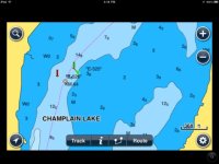
Does the Navionics app for the iPad have maps for Lake Champlain, and does it finally support "course-up" rather than just "North-up"?
 
Lake_Champlain_Screen_Shot.sized.jpg

I don't have the iPad version, but this is a screen shot of a portion of Lake Champlain on the iPhone version of Navionics for the US & Canada running on an iPad. The level of detail up the Champlain Canal, Lake Champlain, Richelieu River, St. Lawrence River, Ottawa River, Rideau Waterway and Trent-Severn Waterway is pretty good, I checked it out zoomed in and zoomed out, and was very pleased with what Navionics has for this area for $15. I did not see anything in the settings to change from North Up to Course up.


Karl":2e7dw1z5 said:
Does the Navionics app for the iPad have maps for Lake Champlain, and does it finally support "course-up" rather than just "North-up"?
 
Back
Top