Navionics on iPad (or Droid)

I use SkipperPro on my iPads and iPhones and last month they came out with a new free version 3.0 i.e:

In Skipper 3.0, we totally changed how the free version works. We abolished the “Trial Mode,” and now most Skipper features work even if you don’t subscribe. Now, the free version of Skipper lets you browse charts online, make routes, record trips, and more. This is much more complete than the simple chart viewer offered for free before.
Upgrading to SkipperPro gives you the following capabilities:

Download charts for offline use
Keep charts automatically up-to-date
Download other map sources for offline use
Use ActiveCaptain data and features


I like to download charts and routes, and overlay topographic maps for shore adventures. Add the Active Captain integration for anchoring and marina information plus ongoing updates, and I think pretty its hard to beat the $10 a year price, not to mention I have access on any apple product via email address and password.
 
So after much research and then second guessing myself.....I ended up buying a new Nexus 7 (2013) model. It is WiFi only but has the internal GPS so it should work great for the Navionics app and others.

I was close to buying an iPad Air2 but couldn't justify the price since it'll be primarily used for the boat and I'll probably never use it anywhere else. I have a new phone and laptop; don't need a expensive tablet. I bought the Nexus 7 for $50 , brand new from a lady on Craigslist! Couldn't pass it up!

I'll be buying the Navionics HD app for $50. Can't wait to try it on the water....
 
Thanks Greg, for passing that along. Don't know if there are any others from around here that might be interested but in case, send me a PM and maybe we can share a ride.

Harvey
SleepyC:moon

1_10_2012_from_Canon_961.highlight.jpg
 
I use navionics on a mini I pad and love it. My buddy just got a boat and so he just baught a mini I pad and the navionics app. For some reason its not tracking his movement though. It shows where he is when he opens the app, but when he pushes "track start" it does not show speed or movement or the yellow line. Any ideas? Under privacy setting he does have location services on for the app....
 
In order for an iPad to navigate, it must be a cellular model. The phone service does not have to be activated for the GPS to work.

The GPS chip is part of the cell service chip, so without the cell service feature, there is no GPS.
 
Catch 22":3ddki7h0 said:
I use navionics on a mini I pad and love it. My buddy just got a boat and so he just baught a mini I pad and the navionics app. For some reason its not tracking his movement though. It shows where he is when he opens the app, but when he pushes "track start" it does not show speed or movement or the yellow line. Any ideas? Under privacy setting he does have location services on for the app....

If he bought a wifi only model iPad Mini, it isn't going to work without an external GPS. If it is a wifi/cellular model, it should work fine without having subscribed to a cellular carrier.

I have used an iPad Mini as a backup chartplotter since that model first came out - great size!
 
My frustration with Navionics is that you need a license for everything, your phone, iPad and MFDs. Vs one subscription that takes care of it all. Wonder if I can share my "freshest data" with my new unit or need another license for my in progress boat.

I use an iPad on my runabout with navionics since my fish finders display is only 5 inches. Sonar and charts on a 5 inch split screen is almost impossible.

H
 
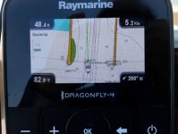
I use a 4.3" Raymarine Dragonfly 4 on the pontoon we have at home. I generally use it on chartplotter mode with a depth readout (and speed/heading/water temp), and switch to the fishfinder mode (chirp) when I want to see bottom contour and texture. You can make a smaller screen work, and even split it, depending on the circumstances.

05PlotterJetties.jpg
 
South of Heaven":dy4bqz03 said:
So after much research and then second guessing myself.....I ended up buying a new Nexus 7 (2013) model. It is WiFi only but has the internal GPS so it should work great for the Navionics app and others.

A lot of good advice here, and quite a bit from last year, but since we are cruising the Great Loop, and using our iPad almost exclusively for navigation (see below), I will add my $0.02 worth.

IF you in fact bought a WiFi only tablet, iPad or Android, it almost certainly does NOT have an internal GPS chip in it. Now, IF a Nexus 7 has a GPS one for some bizarre reason, it is the only one. The GPS chip is part of the package for cell-enabled tablets. On my iPad and iPhone, there is a setting for Location Services (apps or functions that use the GPS chip) for assisting in locating cell towers. You probably have found one way or another by now. Do the navigation apps work with your Nexus 7 out on the water?

As far as apps go, we have Navionics and Garmin Blue Chart Mobile on our iPad. Navionics does not, and never will, have Active Captain support. Don't know the back story, but Jeffrey Siegel, the founder of Active Captain, which he just sold to Garmin, had some kind of animosity for Navionics. So, though while Navionics has far superior cartography to GBCM, the Active Captain support in GBCM makes it far more useful than Navionics. It is the one we run at the helm and consult every morning and night as we decide where we are going and where we want to stay at night, whether in a marina or anchorage. Honestly, we would not leave port now without our iPad running GBCM with Active Captain.

On the charging front, we were using a dime store USB car charger, and the iPad battery kept going down, down, down, even while it was plugged in. So we bit the bullet and bought two Anker Quick Charge 3.0 39W Dual USB Car Chargers and three Anker PowerLine+ Lightning Cable (6ft) Durable and Fast Charging Cable [Double Braided Nylon]. Charging worries are now a thing of the past. Pricey but worth it if you depend on an iPad to run all day.

Now, I said we "almost exclusively" navigate with the iPad, but since it does not have a depth sounder, we also use the Raymarine C-80 Classic, for which we have no CF cards for the Loop. This give us depth and also has the cumulative trip odometer, which just turned 3,000 miles on our Loop yesterday. We also have a Toshiba laptop running Coastal Explorer which is connected to an AIS receiver. We don't even boot this up most days because I cheaped out on the monitor, which is not really daylight viewable - a daylight viewable monitor costs a ton. So we are doing just fine with the iPad and the Raymarine C-80.
 
I don't know about other brands, but all Samsung Galaxy wifi-only tablets have GPS.

I use Navionics, as well as OpenCPN on my Galaxy Tab, both work great.

Also, many aftermarket USB charger ports don't put out enough amps to charge your smartphone or tablet. Blue Sea now makes one that does. Part number 1045, charges at 4.5 amps.

jd
 
A majority of (but not all) Android tablets have built in GPS. On those tablets it is not usually tied to the cellular capability. However, if you need GPS capability it is best to verify it before purchasing a particular tablet.
 
South of Heaven":2cpvvazc said:
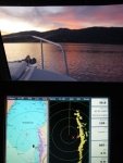
Pat, I've been using the Nexus 7 with Navionics since 2015 when I originally posted this thread. It has an internal GPS and works great. Please see the compatibility page below.

As of recent I've bought a Galaxy Tab A for my new boat.

https://www.navionics.com/usa/support/c ... ty-guides/
Interesting! I guess I stand corrected then on the GPS in a WiFi only Android tablet! i have a Samsung Galaxy Tab 4 but did not bring it with me!
 
My sister-in-law gave me an Galaxy 10 over a year ago because she had two (she got one from her employer as a Christmas gift when she already had one). I've yet to figure out a use for it. I've got a Lowrance HD 5 with Navionics. I've got a camera. I keep my logbook longhand (old school). I've yet to figure out a use for it at home or on board. No idea if it has GPS (like my Lowrance and Standard Horizon already have).

Is there anything useful to do with this on the boat? I've thought about putting all my documentation, owner's manual, etc. on a thumb drive, but it doesn't have a USB port.

Maybe I'll have to start playing video games in a coffee shop?

Mark
 
I have had a couple of tablets on the boat over the years. I can use it as a backup chartplotter and route planner (on or off the boat). Since my chartplotter is older and doesn't support Active Captain, an app on the tablet does.

I put all the manuals for my equipment on it. It is much handier than a stack of books (although there is the eggs all in one basket thing if something goes wrong with it). You can either download the manuals directly to the tablet from the manufacturers website or just email the ones you have to yourself and use the tablet email functions to get and save them.

The tablet is also good for all the usual tablety things: email, web access, reading, games, videos. Depending on your level of addiction to electronic connection to the world, a tablet can be a decent substitute to carrying laptop, at least for shorter trips.

We have a larger tablet which we preload with movies and prerecorded TV programs (via Tivo) to watch in the evenings or during weather layovers. You can also download stuff from Amazon video to watch offline (not sure about NetFlix and the others). Some marinas have enough bandwidth in their wifi that you can watch streaming video directly. A bluetooth speaker box gives decent sound. The tablet can also connect to the stereo system via bluetooth.

The tablet will have either a micro USB or the older Samsung port on it. In either case you can get an adapter that will let you plug in a standard USB thumb drive.

Maybe your sister-in-law can set it all up for you.
 
I have a Samsung Galaxy Tab S2, and have been using it about a year now. It does have a built in GPS and that is one of the functions I really like about it.

It does not connect to to a phone line, but via wifi, I can use it for C-BRATS, Email, and some other things, (Books and music) at times. It is easier to carry around than a lap top.

It is pretty small as tablets go, which is one of the things I have liked about it, but it is big enough. 5 by 7 inch screen, and that works well for use when traveling, (boat or vehicle) with a mapping program, (OsmAnd). I have used that for tracking from Sequim WA all the way to Galveston, and not a glitch. I have used it on the water, and though not for navigation it does make finding the "big picture" really nice. I am considering a RAM mount but not sure which one will fit my uses best yet.

Still no Navionics on it yet. I am pretty happy with my onboard RayMarine C-120 and a smaller Garmin GPS with marine and streets both available. It works to get me where I want to and I'm OK with that.

Harvey
SleepyC :moon

January_2010_342.highlight.jpg
 
The last update on this topic was in August 2017. Since then, has anyone's thinking changed regarding:

—Best tablet navigation software for an Inside Passage trip. Navionics? Some kind of Garmin app (Blue Chart Mobile appears to have been discontinued)? Rose Point Coastal Navigator?

—Best tablet, android or I-pad? (I guess that depends in part on the software.)

—Best tablet mount, and mount location?

Thanks in advance for your ideas.
 
Back
Top