20dauntless
New member
- Joined
- Jan 23, 2008
- Messages
- 879
- Reaction score
- 0
- C Dory Year
- 2008
- C Dory Model
- 22 Cruiser
- Vessel Name
- Retriever and Nordic Tug 37
I just bought the Navionics PC app for Mac and thought I'd share my impressions in case anyone else is thinking of buying it.
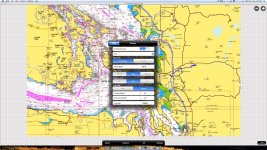
It's basically the iPhone app for a computer. For planning purposes I like it better than GPSNavX for a few reasons. The biggest advantage is that all the charts are quilted together which makes navigation much more seamless. Zooming in and out and panning around does not require loading a different chart which makes looking around much quicker. The Canada charts, which include the area from the Washington/Oregon border north to SE Alaska cost $30, much, much cheaper than buying the Canadian charts for the area. The chart's appear to be identical to the iPhone charts.
Unfortunately, the app does not support a number of useful features. The biggest one missing is the ability to utilize GPS data from a USB GPS puck, so it doesn't really function as a backup when on the boat. You also can't export waypoints or routes. It's unclear whether these features will become available in later releases. For unknown reasons, even when the app takes up the full screen, the map does not on my computer. When displayed on my 27 inch monitor there's a couple inches of gray on each side and an inch or so on the bottom. On my 13 inch laptop monitor, the map displays on the full width but there's still the gray area at the bottom. Not a huge deal, but it would be nice if the map took up the whole area.
For 30 bucks, I think it's a good value for virtual cruising planning. Hopefully Navionics will continue to update and add features like they have with their mobile apps. The addition of GPS functionality and the ability to export waypoints/routes would make this the best Mac charting app, in my opinion.

