Oldgrowth's Boat modifications

oldgrowth

New member
Figured I would post some pictures of my boat projects/modifications.
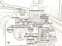
This is what my dash looks like now. I like to see when anything is on and be able to turn everything on or off, from the captains chair.

dash.jpg

Actual photos are HERE in my Boat Projects Album. The photo of the above is towards the end of the album.
 
Dave-

First class work and thinking!!!!

Escellent use of limited space!

Great examples for others to follow.

Great re-wiring job!

Joe.
 
A lot depends on where the radio speaker is. It looks like this may be one of the removable head types where the speaker and power stuff is separate. It's the magnet in the speaker and large masses of metal that futz up the compass....

charlie
 
does the compass work that close to the radio?
It did not seem to affect it in my shed. If you look at the last photo in my Boat Projects Album, you will see there is quite a bit of separation between the radio and compass. I turned everything on, in and on my boat to see if the compass moved and there was none. I also removed the radio and still no change, so I feel fairly confident that there will be no affect. I do carry a hand held compass with me all the time, so will double check when I get on the water.
 
By the why, what month was your Chelan adventure?
The 16th through the 20th of October of 2005
We really enjoyed it. It is the first time we had the boat anywhere other than Riff Lake in Lewis County. It looks like a Chelan gathering is in the works this year and if I can, I will make it.

I too have a Dell Axim, tell me what I need to do to use it as a GPS chartplotter in the boat?
An antenna, software for the Axim, Maps/Charts and a Desktop/Laptop computer to load the information onto the Axim. You should also get at least one 512M Secure Digital Card for the Chart data. I have three for mine. A 512M card for my Marine Charts. A 1G card for my Topographical maps. (They work great for Lake and River navigation.) A 1G card for my street & HiWay navigator maps.

For my marine charts and topo maps I use Outdoor Navigator on my Axim. I believe it was around $15. I download the charts and maps for free here. I don’t know why but Outdoor Navigator is no longer available. However they make another program Pocket Navigator that is much better for $49.95 here.. I may eventually upgrade to Pocket Navigator. The only thing bad about Pocket Navigator is, the Charts cost $$. To get all the charts and maps I want will cost me over $1,000.00 and Free is so much better, even if it doesn’t have all the features I want.

Check the two links above and if you want to use the Axim, I would be more than happy to assist, advice or help in any way I can. I have been using the handhelds for as long as they have been out.

Approximant cost - Antenna $150 - Antenna extension if needed $80
Cards $35 to $50 each - Software $50 - Charts $200 to $2000
 
Whew, you could get most any other GPS chartplotter you wanted when you add that up, especially the charts, which I see are $$Maptech$$. Oh, well, I am fairly well equipped with the C80 and the GPSMAP76 anyway. Not to mention Coastal Explorer on the Pharos GPS puck equipped laptop...I might have to get a GPS for the Axim to use in the car with MS Pocket Streets and Maps though!

oldgrowth":18hppadk said:
An antenna, software for the Axim, Maps/Charts and a Desktop/Laptop computer to load the information onto the Axim. You should also get at least one 512M Secure Digital Card for the Chart data. I have three for mine. A 512M card for my Marine Charts. A 1G card for my Topographical maps. (They work great for Lake and River navigation.) A 1G card for my street & HiWay navigator maps.

For my marine charts and topo maps I use Outdoor Navigator on my Axim. I believe it was around $15. I download the charts and maps for free here. I don’t know why but Outdoor Navigator is no longer available. However they make another program Pocket Navigator that is much better for $49.95 here.. I may eventually upgrade to Pocket Navigator. The only thing bad about Pocket Navigator is, the Charts cost $$. To get all the charts and maps I want will cost me over $1,000.00 and Free is so much better, even if it doesn’t have all the features I want.

Check the two links above and if you want to use the Axim, I would be more than happy to assist, advice or help in any way I can. I have been using the handhelds for as long as they have been out.

Approximant cost - Antenna $150 - Antenna extension if needed $80
Cards $35 to $50 each - Software $50 - Charts $200 to $2000
 
nice looking piece of work there, I especially like the engine indicator lights on the dash, that's a durn good idea that I could see usoing on our boat...as it is now I can't see the lights on the controls.

Chelan? we might be interested in Chelan, it's long been on our list of lakes to explore
 
Pat,

You can get a CF card adapter for that Puck from MS Streets to use it with the Axim. I've got one if you want to see how it works.
 
cool fantom pic of your dash area... that would make for a great looking background for some boating cards. ...or other similar boating pictures processed the same way.
 
Back
Top