Tacoma Narrows Question

Ananda

New member
Here's a question for you Puget Sounders.... I was visiting Gig Harbor this week (by car only, unfortunately). While crossing the Tacoma Narrows bridge on Monday, I looked down on the north side and the water looked like rapids in a river. It was windy that day and I expected whitecaps, but that water looked like it was boiling. I'm an upper river rat, so I don't know anything about salt water and tides, but I'm pretty sure Puget sound doesn't have any rapids. :?

When I returned home over the bridge two days later, it was as calm as a lake. So, what was I seeing? Does the tide do strange things to the water under the bridge? It was pretty impressive, but I was glad I wasn't down on the water!
 
Amateur explanation: The severe tide changes up here are very impressive. Coming from an open ocean State, I noted it immediately my first time out on the Puget Sound. You see what appears to be rapids cause by tidal movement around, over etc obstacles. The Narrows is well known for the rapid movement of water @ tides passing through that narrow channel. If you get wind opposite of the tide, things get messy quickly.

The first time I experienced it I was out on my brother's SMALL 23' sailboat near Baindridge. We hit a tide change which made the water whirlpool. We were under power (small 4 horse outboard) and the engine immediately bogged-down and the boat began to spin/pivot on the keel. Like I said: impressive.
 
What you were seeing was the tide going in or, more probably, out, through the narrow (Narrows) gap between the main northern part of Puget Sound and that part which lies to the south of the Narrows.

If the wind is producing wind waves that are going in the opposite way / direction of the current, it stands the waves up and makes them pretty ugly.

If the wind and the current run the same direction, the two wave forms tend to smooth each other out, and lay the waves down some.

No current and no wind ='s a flat calm, usually.

Experienced salt water coastal / bay sailors, pilots , and captains can simply look at the waves on the water and "read" which way the wind and current are running based on the shape and appearance of the waves.


Areas where two currents and waves forms are interacting are called "rips", and can also be read in the same way. They can be very interesting to take a boat through, and can be dangerous, too!

Bottom contours and island / land forms complicate current flows, just like they do in rivers.

Try boating in Puget Sound, the Sand Juans Islands, and all that lies north to Alaska, and you'll get an education on this subject!

Joe. (formerly a sailor of San Francisco Bay, the California Delta, etc.) :teeth :thup
 
Kathleen, to see tide rips (aka eddy lines, etc.) on the Columbia, you'll have to go close to one of the major points sticking out into the river current on a strong outgoing tide. Near Portland, not many opportunitites to do that. Down nearer the mouth, where I am, it is easier.

Couple spots to see this are off Jetty A near Ilwaco, right at the inner extent of the Columbia River Bar, off Jim Crow Point, maybe 2 miles down from Skamokawa, and when the winds are right, off the lower end of the Port of Astoria.

We just passed through a period of maximum tidal excursion, with highs in the 10-foot range, and lows in the -1 foot range, so some of these were pretty impressive. even so, they pale in comparison to some of the tide rips/current features in the San Juans, and in the passes running through the Gulf Islands (Active Pass, for instance).

Here is a little video of a tug that got into trouble in Skookumchuck Rapids, up from Vancouver a ways, as an illustration of the power of these things: http://boatinginbeautifulbritishcolumbi ... ck-rapids/

Nothing on the Columbia like this, so don't fret too much about it.
 
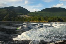
Here's a picture I took at Skookumchuck Rapids a couple years ago. There are lots of places in the Salish Sea and Inside Passage that get fast currents and turbulent water. In some places, wind against current makes the situation worse.

SAM_0749.jpg
 
Kathleen,
The Tide Books that are available for Puget Sound are actually called "Tide and Current Tables". Within them they include the currents at various locations....eg: Admiralty Inlet (off Bush Point), The Narrows, Decdeption Pass, Rosario Strait, San Juan Channel...etc.

For example on Friday May 14, 2010 at 0707 HRS. the maximum current at Deception Pass is a 7.5 Knot current at Ebb Tide.
 
DaveS":20xetswv said:
Kathleen,


For example on Friday May 14, 2010 at 0707 HRS. the maximum current at Deception Pass is a 7.5 Knot current at Ebb Tide.

Someday take a ride (in your car) up to the Deception Pass bridge. You'll get a birds' eye view of the power of the tides. I've watched big sailboats under power try to fight their way through and finally turn back.
 
Someday take a ride (in your car) up to the Deception Pass bridge.

Better yet, take the C-Dory. It's fun playing around in the current, and you have more than enough power to make it through regardless of the speed of current.
 
I have been through the Tacoma Narrows many times in everything from a 12 aluminum car-top boat to a 67 foot Tollycraft and I never felt I was in any danger. Not to understate the importance of knowing the tides and currents, but the Narrows has lots of depth and no obstructions other than the bridge piers. I believe the maximum current speed is about 10 mph.
 
Caution!

Deception Pass can be very dangerous when the current is running. Yes, I know C-Dory people run Deception at various times of the current, and it can be done.

However, a newby should NEVER go thru Deception Pass at anything but SLACK!

It is not just the current speed that is a problem. I have been there when a 40+ft Bayliner came thru against the current at 15-20 knots or so and created standing waves 6 to 10 ft tall. If you get sideways in this mess, those waves can roll your boat!

To learn how to go thru current passes, start by going thru at slack. That is the safest way. After a few transits, you can experiment with times sooner and later than slack. Think about what could happen if you lost power in the middle of the transit. Consider the wind. Wind against current will stand the waves up and make them dangerous.

Also consider that logs can be sucked down to the bottom in a whirlpool and come shooting up to the surface.

All current passes should be considered to be dangerous and treated with respect.
Here is a link to the Deception Pass current tables. Always check the current tables prior to a transit.

http://www.co-ops.nos.noaa.gov/get_...TION+PASS,+(Narrows)+&fldavgd=090&ebbavgd=270

NOAA has current and tide tables available online. Here is another link.

http://www.co-ops.nos.noaa.gov/currents10/tab2pc2.html#120

I have been boating on this coast over 20 years and this advice is meant to keep new boaters to this area safe.
 
Since we launch very close to the Narrows Bridge now Bridges at TOA(Tacoma Outboard Association), , I can tell you that we have rarely launched at a slack tide, and with the almost constant wind ,etc , it can be a a real challenge. We have been told that if you can launch at TOA you can launch anywhere.
When the New Bridge was in the planning stage, there was a firm that wanted to use underwater turbines to generate power because of the fast moving and fast changing tides. too much red tape by the STate , the feds and all the other naysayers squashed it though .
Because of our experiences at the Narrows , Deception Pass has never daunted us in our C-Dory's
 
For 33 years during my sailing days, we raced in San Francisco bay with its full allotment of currents and windy conditions, on everything from small dinghies to big keel boats.

One of the more challenging races was in an 8 foot long El Toro across the mouth of the Golden Gate from Sausalito on the Marin Peninsula side to the Southern side at the St. Francis Yacht Club on the S.F. Peninsula, a distance of about 4 miles, across the currents going in and out of the Gate.

The El Toro, at only 8 feet in length, 38 square feet of sail, and an all up empty weight of about 75 pounds, can only go about 3 knots maximum displacement hull speed, so the currents could easily be stronger than the boat could handle, though we were crossing them at right angles. All in winds from 0 to 25 mph. We often had over 100 boats competing in the race/crossing!

The trick was to get to the other side as fast as possible without being swept out the Gate on an ebb tide toward the Farallon Islands, or, alternately, when the current was flooding the opposite direction, not to be swept past Alcatraz Island and wind up at Jack London's former hangout at the First and Last Chance Bar on the Oakland waterfront!

T'was always a great event and party afterward, too, with steaming hot Irish Coffees served out on the lawn at the St Francis Yacht Club by the Buena Vista Restaurant's staff. A touch of San Francisco Class!

Today, the Americas Cup Trophy resides next door at the Golden Gate Yacht Club courtesy of Larry Ellison (who owns Oracle), BMW, and others.

Damn, I miss the sailing, racing, and sailors!

Joe. :teeth :thup
 
After taking a look at these pictures and videos, and hearing you all talk about your experiences with the interplay of currents, tides and winds.... the constant, powerful current of the Columbia doesn't seem so bad! At least it's all going in the same direction most of the time. I've had some scary sailing experiences in the river when the famous Gorge winds kick up, but luckily land is always close by, often found when keel meets sandbar.

Those Skoomkumchuk rapids are something to behold! The usual bucolic pictures of the Sound are not representative, it appears. I'll have to develop a lot more courage -- and knowledge -- to venture forth up north, I guess. :shock:
 
Kathleen, The invite is still out! Come up to the South Sound
and we can do some cruising. It is a great place, with lots to see
and do.

Robbi
 
Thanks, Robbi! I was thinking of you when I crossed the Narrows bridge. I'll enjoy going out much more knowing you're so familiar with that area. Hope to make that happen as we move into warmer weather.

Best,

Kathleen
 
Kathleen,

Tht C-Dory is a skookum item itself. You'd have no problems running the passes in the Gulf Islands. After you have gone across a few current rips and small whirlpools, you'll really appreciate the value of a powered vessel in rough water.
 
Ha, Dave! :lol: Now I have a new word to add to my vocabulary. When I googled "skookum", I found out it means "smart, intelligent, well done, bright, agile", according to the Skookum boats website: http://steelheader.com/index.htm. They have a video of their pontoon boat going down some rapids. Looks like fun!
 
Ananda":2cqlru3f said:
Here's a question for you Puget Sounders.... I was visiting Gig Harbor this week (by car only, unfortunately). While crossing the Tacoma Narrows bridge on Monday, I looked down on the north side and the water looked like rapids in a river. It was windy that day and I expected whitecaps, but that water looked like it was boiling. I'm an upper river rat, so I don't know anything about salt water and tides, but I'm pretty sure Puget sound doesn't have any rapids. :?

When I returned home over the bridge two days later, it was as calm as a lake. So, what was I seeing? Does the tide do strange things to the water under the bridge? It was pretty impressive, but I was glad I wasn't down on the water!

Hi,
About five years ago at the Seattle Boat Show I met Kevin Monahan, author of "Local Knowledge" A Skippers Reference Tacoma To Ketchikan, 142 pages. It's a jewel because its true to its title "Local Knowledge", and applies to much more than Tacoma to Ketchikan. I really appreciated the section on managing tidal rapids. There are drawings and photos that correlate with concise written explanation to help the reader understand general principles, characteristics and rules of tidal rapids. I like it because in explaining it as he has it helps understanding your marine environment in other areas as well.

Thanks for reminding me to revisit and reread.

Tom
 
Back
Top