Why You Need an iPad and the Navionics App

Pat Anderson

New member
OK, this is for our iPad-less friends. Those of you who already have your iPad know all this, but the more I use this app, the more amazed I am at just how capable it is.

We have a 16GB 3G original iPad 1. All these screen shots are from the $15 Navionics US & Canada iPhone app, which runs great on the iPad and renders charts nicely because they are vector charts.

This is all from my planning / dreaming for the Great Loop in 2014. We need to do the GL in chunks over a couple of years because we need to come home every couple of months to see our granddaughter. Leg 1 probably starts in Paducah, KY, and goes to Apalachicola, FL.

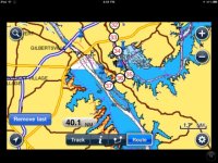
I started with a marker in Paducah, added to Favorites, so I can quickly get to that point on the charts no matter what else I am doing. The marker is the push pin.
Navionics_1.sized.jpg

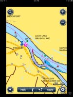
If you like, you can overlay the chart with the Google satellite view.
Navionics_7.sized.jpg

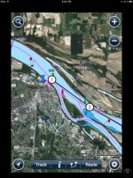
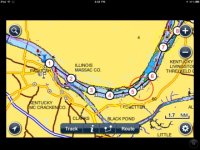
You can enter routes, and each route can have up to 99 waypoints. This route is from Paducah to Kentucky Lake via the Cumberland River. Here is the start...
Navionics_4.sized.jpg

...and the end.

Navionics_5.sized.jpg

You can easily access route information.
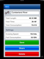
Navionics_6.sized.jpg

Tapping the little i takes you to this screen
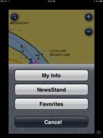
Navonics_2.sized.jpg

...and tapping Favorites takes you to this screen
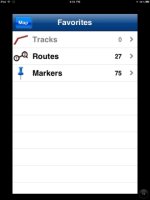
Navionics_3.sized.jpg

where you can quickly access all your markers and routes. As you can see, I have 75 markers and 27 routes entered here, all parts of the Great Loop.

I have not played with tracks yet.

Naturally, I have the same app and chart data on my iPhone!


Pat,

Is that only available for I-pad, or I-phone? What about Kindle Fire or something with the android system?

Yep, I don't have an I-phone but am beginning to explore. I just heard they have phones now that you don't have to wire to the wall. :oops:

Harvey
SleepyC :moon
 
My grandfather helped build the Kentucky lake dam working as part of the TVA, and resided there in Calvert. Interesting seeing the charts, as I spent many a summer fishing those waters as a kid.
 
thanks

Great tutorial

The Apple Store has restocked a selection of factory-refurbished Apple iPad 2 tablets, as listed below. With free shipping, each is up to $100 off and tied with last week's mention as the lowest total price we could find. Sales tax is added where applicable. Each carries a 1-year Apple warranty, the same as new units.

http://dealnews.com/Refurbished-Apple-i ... 38360.html

The deals:

Refurbished Apple iPad 2 16GB WiFi in Black or White for $419
refurbished Apple iPad 2 32GB WiFi in Black or White for $499
refurbished Apple iPad 2 64GB WiFi in Black or White for $599
refurbished Apple iPad 2 16GB WiFi + 3G in Black or White for Verizon Wireless for $549
refurbished Apple iPad 2 16GB WiFi + 3G in Black or White for AT&T for $549
refurbished Apple iPad 2 32GB WiFi + 3G in Black or White for Verizon Wireless for $629
refurbished Apple iPad 2 32GB WiFi + 3G in Black or White for AT&T for $629
refurbished Apple iPad 2 64GB WiFi + 3G in Black or White for Verizon Wireless for $729
refurbished Apple iPad 2 64GB WiFi + 3G in Black or White for AT&T for $729
 
Pat do you know if it works with Droid phone ? I cant get a I-phone until next year when my sprint contract is up I can get a i-phone from sprint next summer . I stay with sprint for a few reasons one is a corporate discount and unlimited everything .Is the I-pad 4g or 3 g and is it worth the difference ? so it does everything an i-phone will do but is not a phone right ? Sorry still getting out of 19th century electronics

I have downloaded Nutichartslite also tide predictions and wind observations that seems to get me through .

Hope to see you guys in a few years doing your Great Loop Take care Jim and Loree
 
Hi Harvey,

Yep, similar with the Navioinics app on my Droid Bionic. Pat is using the iPhone app on the iPad - totally functional. Looks even better with the iPad app, but the cost is more: $34.99 vs $14.99. At these prices, you can buy a bunch of apps for less than the price of one CF chip for a chartplotter.

I've probably said this before, but for the cost of a couple chartplotter chips, you can buy an iPad and apps. Same apps available for the iPhone and Android phones, but the size of the screen on the iPad makes it our preference on the boat. I really like the tide info graphic display on the Navionics app.

Best wishes,
Jim
 
A comment on the refurished iPads - be sure you get a 3G not WiFi only model. You don't need the data plan but only the 3G model has the GPS chip, which of course is the whole point out on the water. You don't need a data plan, you can download the chart data via WiFi. You need data for the satellite overlay but that is foo foo anyway.

On the Kindle Fire, that is a very good question, and we will need someone who owns one to tell us. And possibly Amazon will see the light and open up the Kindle Fire to the whole range of Android apps. But right now, Amazon is tightly controlling the apps you can run on the Kindle Fire, and they really only want you to use it to read / view / listen to Amazon content, not use it as a general purpose machine like the iPad.

There is a whole slug of Android tablets about to be released, however, which ought to run Navionics just fine. They will have much lower prices, starting at about $250, according to what I have read. Adios, little handheld backup GPSes!
 
Hi Jim,

The iPad is available with wifi only or wifi/3G. Even if you buy a 3G iPad (and that is the only one I recommend for nav use because it has a built-in GPS chip, the wifi only model does not have the GPS chip), you don't have to subscribe to any cell carrier.

As far as the Navionics apps go, the Android versions are very similar to the iPad/iPhone versions.

I guess I have to say that, while I am a big fan of the iPad and the Navionics apps, I don't feel that they are a "must have" item. If you don't currently use a chartplotter or travel out of one area a lot, then it's no big deal. But, if you want an inexpensive alternative to a full-featured chartplotter, an easy way to do trip planning, a place to store and play your iTunes library, a bunch of other apps you didn't know you needed (weather, financial, etc), a way to connect to the internet and e-mail, a photo viewer and storage, eBook reader (hundreds of books in the space of a magazine), and a fun computer-like gizmo, well, this is the pick of the litter for tablets.

Joan wasn't sure what I "needed" an iPad for when we first got it. Then, she started using it. She now uses that way more than her computer. In fact, she didn't see a reason for a smart phone until after using the iPad; she now really likes her iPhone. With these devices, the more you use them, the more uses you find for them.

With Joan having an iPhone and me the Droid Bionic, it has given me the perspective of plenty of hands on with both. The current iPhone is 3G, but that really isn't a big deal in most places. We recently started receiving 4G at our home (prior to that, any cell reception was moderately crappy), and the speeds with that are impressive - between 8 and 14 mg... compared to .5 to .8 mg most of the time with 3G. We did away with our land lines, DSL, and cable modem years ago, since we are traveling more than we're home. We currently use the Droid Bionic as our wifi hot spot, making that the internet connection for our computers and iPad. If you are in an area where 4G is available, it is a remarkable difference, making me feel even better about my Droid purchase... otherwise, the iPhone is a more integrated experience. They're actually more alike than they are different.

Hope that helps.

Best wishes,
Jim

On edit: looks like Pat and I said a lot of the same things. Sorry for any repetition.
 
I am posting this reply on my Ipad2. I use the Navionics app every time I go out. I generally use the chart plotter set for a big picture and the iPad for more detail. Given the age of my chart plotter, the iPad presents a much better picture. For me, I wouldn't be able to find my crab pots without the iPad. I'd also recommend a good ram mount to hold the iPad and "freezing" the screen to keep it from rotating in rough water.

I also have apps for NOAA radar, two for showing ship traffic, a weather app, and drag queen for setting an anchor watch.
 
I agree that the iPad is a fantastic addition to the boat and is also useful in a multitude of other situations.

I bought a RAM mount and installed it on the overhead shelf. This holds the iPad securely in all conditions I've been in so far, including a nasty gale last week in the San Juans with steady winds of 30-40 knots. I use iNavX and Navimatics mostly. I think iNavX is slightly more fully featured than Navionics but is also more expensive. I don't have a wifi NMEA multiplexer, but theoretically you can link an iPad running iNavX into any NMEA network on your boat, gaining access to engine data, AIS, heading sensors, etc. Navimatics has offline ActiveCaptain support and is worth buying for that feature alone.

The iPad has lots of uses besides navigation as well. Right now, I'm sitting on the boat at the Blake Island dock listening to Pandora from my iPad. Last night I watched a movie on the iPad. I've also loaded all the manuals for equipment on the boat into iBooks. This allows instant, searchable access to every manual when something goes wrong.
 
Just a quick note.

There are 8 Navionics Mobile apps in the App Store.
Marine & Lakes: USA,
Marine & Lakes: USA & Canada,
Marine: Carib & S.America,
Marine: Europe,
Marine: UK & Holland,
Marine: Denmark & Greenland,
Marine: Australasia & Africa,
Marine: Australia & NewZealand.

Not to rain on Pat's parade, Navionics has several training videos located at

http://www.navionics.com/NavionicsVideos.asp
 
20dauntless":vo0ydlgb said:
I agree that the iPad is a fantastic addition to the boat and is also useful in a multitude of other situations.

I bought a RAM mount and installed it on the overhead shelf. This holds the iPad securely in all conditions I've been in so far, including a nasty gale last week in the San Juans with steady winds of 30-40 knots. I use iNavX and Navimatics mostly. I think iNavX is slightly more fully featured than Navionics but is also more expensive. I don't have a wifi NMEA multiplexer, but theoretically you can link an iPad running iNavX into any NMEA network on your boat, gaining access to engine data, AIS, heading sensors, etc. Navimatics has offline ActiveCaptain support and is worth buying for that feature alone.

The iPad has lots of uses besides navigation as well. Right now, I'm sitting on the boat at the Blake Island dock listening to Pandora from my iPad. Last night I watched a movie on the iPad. I've also loaded all the manuals for equipment on the boat into iBooks. This allows instant, searchable access to every manual when something goes wrong.

I've still not found a ram mount for my iPad that I like or should say trust. If you could post a link to the mount that you like I sure would appreciate it...

H :wink:
 
I have the Iphone 4S and Kindle Fire. Love the Navionics app. but haven't seen the need to acquire an Ipad for it. While underway, I have the Iphone mounted with a windshield mount, extending to a clear view while I'm on the helm. Above me is the Garmin 172 chartplotter and in the berth is my laptop with charts, just in case. The Iphone resolution is sufficient for me to navigate at plot courses....and it doesn't have glare problems.

The Iphone is also my hotspot, allowing me to have internet capabilities with my Kindle and laptop.

Regarding the Kindle Fire, it has no GPS capabilities. I primarily use it as a convenient web browser, ebook reader, and to check my emails. I prefer 7 inch tablets to 10 inch ones, so down the road when tablets are updated and improved, I can see myself replacing the Iphone Navionics program with a 7 inch tablet.

I echo those who love the Navionics app. Outstanding, user friendly program.

-Greg
 
Raymarines new line of chart plotters are now wireless. What this means is that you only need one chart plotter at the helm ,and if you get a ipad or other wireless device, you can then see every thing on the chart plotter on the ipad/phone/or other device. That includes radar, fish finder, ais etc.. any thing that is on the one will be on the other. much cheaper and easier to install then a second chart plotter at another station. I am willing to beat that Garmin will be doing the same in the future.
 
One of the coolest parts of the new Raymarine E7 is that routes can be wirelessly exported from an iPad or iPhone running Navionics to the chartplotter, which can then drive the autopilot. I still haven't figured out how to get routes from my iPad to my C80 and have all but given up. Apparently it also has an all new user interface including touchscreen and real buttons. There sure have been a lot of advances in marine electronics since I got mine back in 2008!
 
pat I still have a c-80 and don't mind the interface and menus at all. I know that the garmin is better but they all work basally the same. My biggest complaint with the c-80 was the depth finder. it never gave arches for fish just blobs and clouds.

Like I said iam sure the garmin and others will be wireless or bluetooth in the future.
 
Back
Top